-
09-19 18:50...19日至20日,浙江、安徽、江苏、上海等地部分地区将有中到大雨,局地暴雨或大暴雨;9月19日08时至20日08时,黄海南部海域、东海大部、杭州湾、长江口区、浙江沿海、福建沿海、上海、江苏东南部将有6-8级、阵风9级的大风,其中东海北部和杭州湾及长江口的部分海域、上海沿海、浙江东北部沿海、江苏东南部沿海风力可达9-10级... 1
-
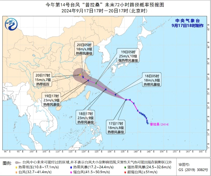
09-19 12:00...中心附近最大风力8级(18米/秒)。未来它将以每小时35到40公里的速度向西北方向快速移动,强度缓慢加强,18日起移速减缓,18日晚上移入东海东部海面。预计19日下午到晚上,“普拉桑”将登陆浙江沿海。今年第14号台风“普拉桑”未来72小时路径概率预报图(央广网发来源:中央气象台)同时,根据浙江省气象台预计,未来七天浙江... 0
-
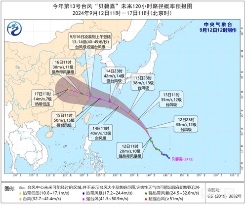
09-19 11:40...预计“贝碧嘉”将以每小时25-30公里的速度向北偏西方向移动强度逐渐增强。福建省气象台12日11时发布“台风预警Ⅳ级”。根据《福建省防汛抗旱防台风应急预案》,福建省防指决定12日11时启动防台风Ⅳ级应急响应。今年第13号台风“贝碧嘉”未来路径概率预报图(截图来源:中央气象台官网)记者从福建省气象台获悉,受台风“贝碧嘉”... 0
-
09-18 18:10...预计“普拉桑”将以每小时45-50公里的速度向西北方向快速移动强度变化不大并将于19日下午到夜里在浙江沿海登陆风雨影响今天傍晚闽外渔场最大风力可达7~8级阵风9~10级今天夜里闽外渔场、闽东渔场东部最大风力可达8~10级阵风11级19日上午闽外渔场、闽东渔场东部最大风力可达8~9级阵风10~11级今天,副高减弱受台风“... 0
-
09-18 16:20...暴雨区内中小河流可能发生超警以上洪水。中国天气网首席气象分析师信欣表示,从目前预报来看,“摩羯”登陆海南万宁到广东电白一带沿海的中心最大风速可达48-55米/秒,强度介于2014年台风“威马逊”和2005年台风“达维”之间,可能会是近十年影响或登陆海南最强的台风。此外,广东雷州半岛也是“摩羯”的潜在登陆地。历史上9月登... 3
-
09-18 11:10...河南中东部、安徽西北部、山东西南部等地部分地区有大到暴雨,河南东部、山东西南部等地部分地区有大暴雨(100~220毫米)。明天,河南等地的降雨将趋于结束。专家提醒,河南、安徽西北部等地公众需继续提高警惕,防范局地强降雨可能引发的中小河流洪水、山洪、地质灾害及城乡积涝等,远离山区、河谷、地势低洼的地区,注意出行安全。图片... 0
-

-
09-18 07:00...12-14米/秒)。大风预报:9月17日14时至18日14时,江苏西北部、安徽北部、河南东部、山东南部等地部分地区将有5-6级风,阵风7-8级,上述地区江河湖面和山区的风力有7-8级,阵风9级。降水预报:9月17日14时至18日14时,安徽北部、河南东部、河北南部、山东西部、江苏西北部等地部分地区有大到暴雨,其中,河南... 0
-
09-18 03:50...下一场台风“普拉桑”也已经生成。今年九月以来的秋台风,为何如此频繁?九月以来秋台风出现的频率较历史同期偏活跃中央气象台高级工程师王皘:今年的台风“摩羯”,还有第13号“贝碧嘉”已经相继影响了我国,它们的影响强度也是超过历史同期的,也就是说秋台风刚刚拉开序幕,但它的影响已经不容小觑了。在过去常年的9月上旬和中旬,大约有1... 0
-
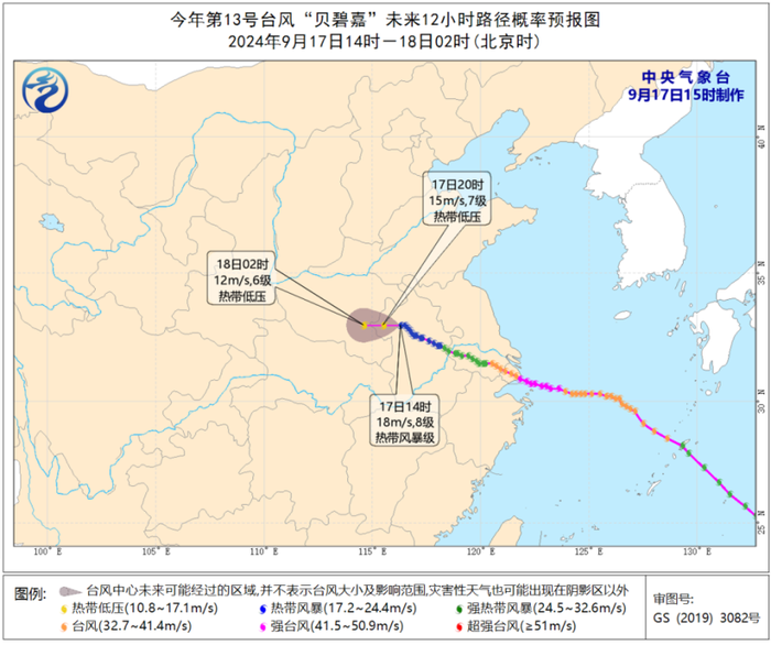
09-18 03:00...而多台风相互作用会导致“普拉桑”和南海新生台风未来路径、强度及风雨分布预报均存在较大的不确定性。“贝碧嘉”可能在河南滞留徘徊据中央气象台消息,17日10时,“贝碧嘉”位于安徽省淮南市境内。预计,其将以每小时15公里左右的速度向西偏北方向移动,强度继续减弱,将于17日夜间移入河南省境内。王海平介绍,受“贝碧嘉”影响,17... 0
-
09-17 22:00...18日起移速减缓,18日晚上移入东海东部海面,19日下午到晚上将在浙江沿海登陆(强热带风暴级,10—11级,25—30米/秒),之后强度逐渐减弱。“贝碧嘉”继续深入内陆影响安徽河南等地今明两天(17日至18日),受台风“贝碧嘉”减弱后的残余系统影响,安徽、河南等地部分地区仍有强降雨,局地或现大暴雨。中央气象台继续发布暴... 0
-
09-17 20:30...普拉桑紧随贝碧嘉再次影响华东地区,上海、浙江、江苏和安徽等地台风灾害风险高,部分地区可能重复受灾,需高度关注。一、台风贝碧嘉以强台风级登陆上海浦东,是1949年以来登陆上海最强台风,将继续影响河南安徽等地今年第13号台风贝碧嘉于9月10日在西北太平洋洋面生成,之后一路向西北转偏西方向移动,强度逐渐增强;于16日7时30... 0
-
09-17 05:50...浙江、江苏也在此次台风影响范围内。海南、广东刚刚应对完摩羯,下一场台风普拉桑也已经生成。今年九月以来的秋台风,为何如此频繁?九月以来秋台风出现的频率较历史同期偏活跃中央气象台高级工程师王皘:今年的台风摩羯,还有第13号贝碧嘉已经相继影响了我国,它们的影响强度也是超过历史同期的,也就是说秋台风刚刚拉开序幕,但它的影响已经... 2
-
-
09-16 18:20...7度、东经122.5度,中心附近最大风力有14级(45米/秒),中心最低气压为955百帕,七级风圈半径180-200公里,十级风圈半径70-100公里,十二级风圈半径40公里。预计,“贝碧嘉”将以每小时25公里左右的速度向西偏北方向移动,将于今天早晨到上午在上海浦东到奉贤一带沿海登陆(强台风级,14级,42-45米/秒... 0
-
09-16 13:50...“贝碧嘉”将以每小时25公里左右的速度向西偏北方向移动,将于今天早晨到上午在上海浦东到奉贤一带沿海登陆(强台风级,14级,42-45米/秒),登陆后继续向西偏北方向移动,强度逐渐减弱。大风预报:9月16日08时至17日08时,黄海南部、东海西部、浙江北部、江苏中部和南部、安徽东部将有6-8级、阵风9-10级的大风,东海... 0
-
09-16 13:00...2022年第12号台风“梅花”是登陆上海强度最强的台风。2022年9月15日,第12号台风“梅花”于0时30分前后在上海奉贤沿海再次登陆,登陆时中心附近最大风力有12级(35米/秒),中心最低气压为975百帕。有网友说,经过一夜观察,“贝碧嘉”好像影响不大。气象专家解释,主要原因是“贝碧嘉”目前强风雨偏在它的东侧。随着... 0
-
09-16 01:40...等18个站突破历史极值。高温为何持续出现?中央气象台首席预报员张涛分析,高温天气出现的区域主要受副热带高压控制,受副高控制的地方以晴好天气为主,有利于持续的日晒辐射加温。此外,副高控制区域盛行下沉气流,晴热少云,也利于空气下沉增温。“川渝地区还因为地处四川盆地,不利于热量水平交换。周围山地阻挡使得盆地内热空气无法排出,... 0
-
09-15 20:40...十级风圈半径80-100公里,十二级风圈半径40公里。预计,“贝碧嘉”将以每小时20-25公里的速度向偏西方向移动,强度还将有所加强,穿过舟山群岛后,将于16日早晨至上午在浙江舟山到江苏启东一带沿海登陆(台风级或强台风级,13-14级,38-45米/秒),最大可能以强台风级在浙江平湖到上海浦东一带沿海登陆(14级,42... 0
-
09-13 02:50...我省沿海海面、浙北和沿海的部分高山区出现8~10级大风,平原地区大部也出现5~7级阵风。高温被直接扑灭。10日全省仅三地突破高温线,11日缩减到两地。杭州11日早晨最低气温24.1℃,为下半年以来的最低值。不过,副热带高压实在强势,今天,高温又要反扑。到明天,衢州、金华地区甚至还会出现38℃以上的高温。杭州稍微好一点,... 0
-
-
09-09 20:30...江北、九龙坡、南岸、渝中、大渡口、北碚、沙坪坝、潼南、合川、铜梁、璧山、江津、綦江、长寿、涪陵、丰都、梁平、开州、云阳、巫溪、高新区、两江新区等22个区县最高气温超过37℃,最高达39.1℃(巫溪)。登陆越南后的“摩羯”昨天迅速减弱为热带低压,中央气象台已对其停止编号。看↓截至8日13时,9月5日以来“摩羯”制造了多少... 0
-
09-09 15:10...目前南海季风非常活跃,维持了一条东西向赤道辐合带,为“摩羯”提供了能量维持的十分有利条件。特别是在9月4日,“摩羯”西侧的孟加拉湾和其东侧日本以南洋面上均存在热带低涡系统,这两个系统将“摩羯”夹在中间,并为其注入了大量水汽,促使其得以发展强大并维持。另外,9月以来,南半球的冷空气活动频繁,导致越赤道气流持续增强,也助力... 6
-
09-09 10:30...这在一定程度上‘压制’了‘摩羯’向北移动的幅度,导致其登陆次数较多。”那么,“摩羯”为何能在超强台风级别维持64小时?张玲表示,这主要归因于季风活跃等外部环境的叠加效应。目前,南海季风非常活跃,维持了一条东西向赤道辐合带,为“摩羯”提供了能量维持的有利条件。特别是在9月4日,“摩羯”西侧的孟加拉湾和其东侧日本以南洋面上... 0
-
06-18 09:00...内蒙古东南部和中部、辽宁中部和西部、新疆南疆盆地、北京中南部、天津中西部和南部、河北中南部和东北部、云南南部、广西西部、海南岛西北部等地有35~36℃高温天气。其中,内蒙古东南部、辽宁西部、新疆南疆盆地等地的部分地区最高气温37~39℃,局地可达40℃以上。中央气象台今天早上6时继续发布暴雨黄色预警:预计,18日8时至... 1
-
-
-
本页Url:
-
2024-09-21-05:17 GMT . 添加到桌面浏览更方便.
-

