-
09-20 03:30...受强冷空气影响,我市将出现偏北大风。伴随大风,21日夜间起,气温也将自北向南先后下降,全市过程平均降温幅度8~10℃。最低气温将出现在周日夜间到周一早晨,市区及沿海地区15℃左右,内陆地区13℃上下。下周一白天气温开始回升,最高气温全市26℃左右。请大家根据气温变化,适时调整着装,谨防感冒。此次冷空气影响期间,风力较强... 0
-
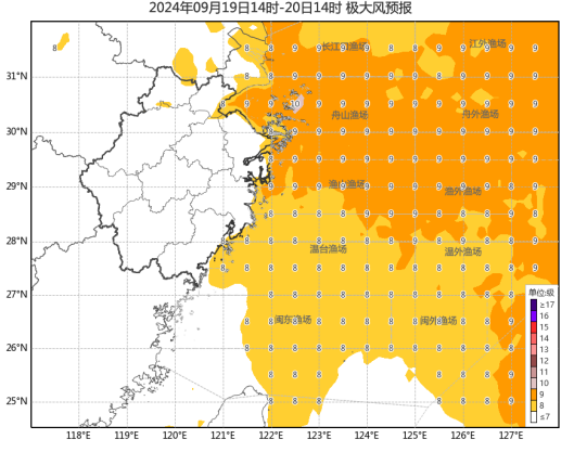
09-19 18:50...19日至20日,浙江、安徽、江苏、上海等地部分地区将有中到大雨,局地暴雨或大暴雨;9月19日08时至20日08时,黄海南部海域、东海大部、杭州湾、长江口区、浙江沿海、福建沿海、上海、江苏东南部将有6-8级、阵风9级的大风,其中东海北部和杭州湾及长江口的部分海域、上海沿海、浙江东北部沿海、江苏东南部沿海风力可达9-10级... 0
-
09-19 17:20...23-30米/秒),之后强度逐渐减弱。“普拉桑”路径概率预报图(央广网发来源:中央气象台)浙江省气象台预计,9月19日东海海域有9~10级局部11级阵风;19日浙中北沿海海面有8~9级局部10级阵风,沿海和浙中北部分地区阵风5~7级,江河湖面和高山区7~9级。19日到20日白天为降水集中期,全省有中到大雨,其中沿海和浙... 0
-
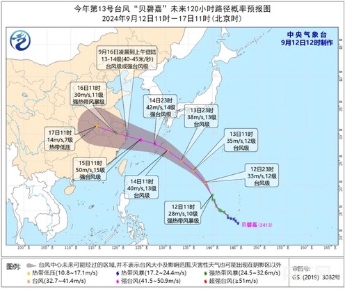
09-19 11:40...预计“贝碧嘉”将以每小时25-30公里的速度向北偏西方向移动强度逐渐增强。福建省气象台12日11时发布“台风预警Ⅳ级”。根据《福建省防汛抗旱防台风应急预案》,福建省防指决定12日11时启动防台风Ⅳ级应急响应。今年第13号台风“贝碧嘉”未来路径概率预报图(截图来源:中央气象台官网)记者从福建省气象台获悉,受台风“贝碧嘉”... 0
-
09-18 21:00...并将于19日下午到晚上在浙江沿海登陆8-10级,20-25米/秒之后强度逐渐减弱。大风预报:9月18日08时至19日08时,东海大部海域、台湾海峡、巴士海峡、南海大部海域、琼州海峡、北部湾将有6-8级、阵风9级的大风,其中东海部分海域风力可达9-10级、阵风11-12级。降水预报:9月18日08时至19日08时,浙江沿... 0
-
09-18 18:40...闽外渔场最大风力可达7~8级,阵风9~10级,今天夜里闽外渔场、闽东渔场东部,最大风力可达8~10级,阵风11级。19日上午闽外渔场、闽东渔场东部最大风力可达8~9级,阵风10~11级。今天,副高减弱受台风“普拉桑”外围环流影响,全省多云,沿海地区的部分和其余地区的局部有阵雨或雷阵雨。19日,全省多云到阴有阵雨或雷阵雨... 0
-

-
09-18 18:10...预计“普拉桑”将以每小时45-50公里的速度向西北方向快速移动强度变化不大并将于19日下午到夜里在浙江沿海登陆风雨影响今天傍晚闽外渔场最大风力可达7~8级阵风9~10级今天夜里闽外渔场、闽东渔场东部最大风力可达8~10级阵风11级19日上午闽外渔场、闽东渔场东部最大风力可达8~9级阵风10~11级今天,副高减弱受台风“... 0
-
09-18 07:40...早晨5点钟位于琉球群岛那霸市东南方向约630公里的西北太平洋洋面上,就是北纬22.8度、东经132.6度,中心附近最大风力有9级(23米/秒),中心最低气压为990百帕,七级风圈半径200-280公里。预计,“普拉桑”将以每小时35-40公里的速度向西北方向快速移动,强度有所增强,18日晚上移入东海东部海面,并将于19... 0
-
09-18 02:30...偏北风3到4级,阵风5到6级,气温18~27℃。9月23日:晴天到多云,偏北风3到4级,阵风5级,气温18~27℃。9月24日:晴天到多云,偏北风3级,气温20~29℃。气温波动较大记得及时增减衣物又是一年中秋月又是万家团圆时节日期间家家设宴庆祝团聚很多人在吃上相对平时来说会比较放纵所谓“病从口入”在这里提醒大家关注我... 0
-
09-17 23:00...降水云团正在影响中南部县区,已出现短时强降水和雷电。预计本次降水过程平均累积降水量50~100毫米,局部150毫米以上,伴有雷电、短时强降水和8~10级雷雨阵风,最大小时降水量40~70毫米。目前,降水云团正在影响临沂市中南部县区,降水移动缓慢,并继续东移北抬。市气象台预计,今天上午,临沂市中南部县区强降水仍将持续,将... 0
-
09-17 20:30...普拉桑紧随贝碧嘉再次影响华东地区,上海、浙江、江苏和安徽等地台风灾害风险高,部分地区可能重复受灾,需高度关注。一、台风贝碧嘉以强台风级登陆上海浦东,是1949年以来登陆上海最强台风,将继续影响河南安徽等地今年第13号台风贝碧嘉于9月10日在西北太平洋洋面生成,之后一路向西北转偏西方向移动,强度逐渐增强;于16日7时30... 0
-
09-17 19:50...其他县市28℃~30℃;最低气温:西部、北部19℃~21℃,其他县市21℃~23℃。15日,全省多云间阴天,东部有阵雨、雷阵雨。最高气温:西南部、东南部30℃~32℃,其他县市25℃~27℃;最低气温:西部山区18℃~20℃,其他县市21℃~23℃。受南下冷空气影响,明天到15日,全省偏北风3到4级,阵风6级左右。16... 0
-
-
09-17 18:20...闽外渔场、闽东渔场东部最大风力可达8~10级阵风11级;19日上午,闽外渔场、闽东渔场东部最大风力可达8~9级阵风10~11级。气象部门表示,警惕海上大风灾害风险,18日傍晚到19日上午闽外、闽东渔场东部有海上大风灾害风险该区域航行或作业船只注意及时避开影响区域海上作业平台注意防范大风影响。昨天(16日)全省多云到阴,... 0
-
09-16 23:00...南京、镇江等地区将有10级-11级,江淮之间8级-10级,淮北地区6级-7级的阵风。9月14日10时30分,江苏海事局启动防台风Ⅲ级响应,要求各港航企业和船舶认真落实防台措施。9月15日12时起,江苏辖区所有渡船、旅游客船停运,所有船舶停止航行。南通市农业农村局要求各地组织在海渔船于9月14日12时前进港避风,所有渔船... 0
-
09-16 18:20...7度、东经122.5度,中心附近最大风力有14级(45米/秒),中心最低气压为955百帕,七级风圈半径180-200公里,十级风圈半径70-100公里,十二级风圈半径40公里。预计,“贝碧嘉”将以每小时25公里左右的速度向西偏北方向移动,将于今天早晨到上午在上海浦东到奉贤一带沿海登陆(强台风级,14级,42-45米/秒... 0
-
09-16 13:50...“贝碧嘉”将以每小时25公里左右的速度向西偏北方向移动,将于今天早晨到上午在上海浦东到奉贤一带沿海登陆(强台风级,14级,42-45米/秒),登陆后继续向西偏北方向移动,强度逐渐减弱。大风预报:9月16日08时至17日08时,黄海南部、东海西部、浙江北部、江苏中部和南部、安徽东部将有6-8级、阵风9-10级的大风,东海... 0
-
09-15 23:40...部分地区大暴雨,提醒大家注意防范。中秋期间全省没有高温天气,最高气温30℃到33℃;最低气温24℃到28℃。三天预报13日20时到14日20时,江淮之间北部和淮北地区阴有阵雨或雷雨,其中沿淮和淮北地区中到大雨,局部暴雨,其他地区多云。最高温度:沿江和苏南地区34~35℃,西北部地区29~30℃,其他地区32℃左右。14... 2
-
09-15 23:40...需及时调整着装受冷空气影响10-11日和13-14日全省自北向南转偏北风4到5级阵风7级左右注意提前加固室外临时搭建物做好防范本周我省多分散性阵雨、雷阵雨预计今天下午到夜里局部大雨或暴雨并伴有短时强降水等强对流天气明天,淮河以北有分散性阵雨、雷阵雨11日,黄河以南有分散性阵雨、雷阵雨大家外出时建议随身携带晴雨伞,以备不... 0
-
-
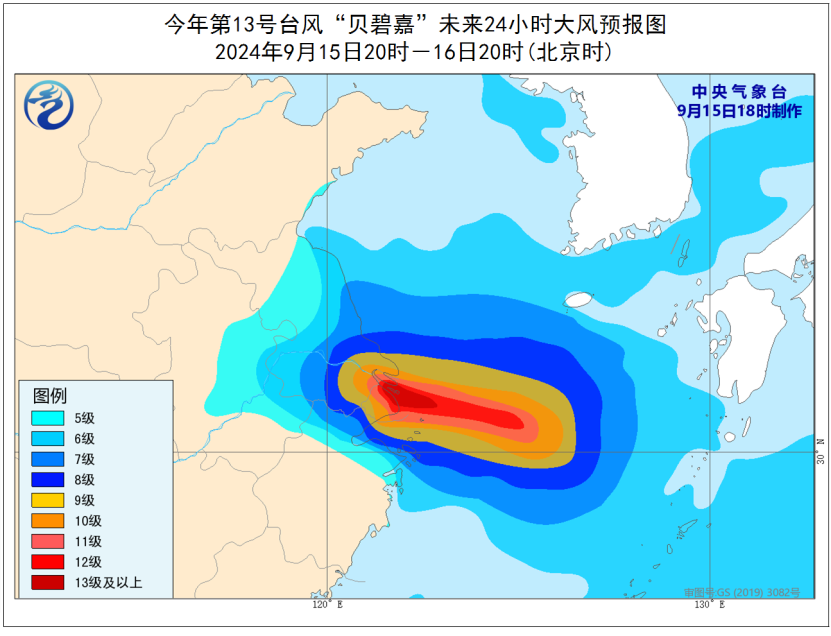
09-15 20:40...十级风圈半径80-100公里,十二级风圈半径40公里。预计,“贝碧嘉”将以每小时20-25公里的速度向偏西方向移动,强度还将有所加强,穿过舟山群岛后,将于16日早晨至上午在浙江舟山到江苏启东一带沿海登陆(台风级或强台风级,13-14级,38-45米/秒),最大可能以强台风级在浙江平湖到上海浦东一带沿海登陆(14级,42... 0
-
09-15 20:30...将于16日凌晨至上午在浙江台州到江苏启东一带沿海登陆(台风级或强台风级,12~14级,35~42米/秒)。台风“贝碧嘉”登陆后继续向西北方向移动,穿过浙江并进入安徽省中部,对安徽省造成明显风雨影响。据安徽省气象台预报,9月15日至17日(中秋假日期间)受台风“贝碧嘉”影响,安徽省有强降水并伴有大风天气。15日夜里开始,... 0
-
09-14 11:20...海南省气象部门提醒中秋节假期(9月15日17日),海南全岛天气总体较好,气温适宜,大部分时段有利于户外活动。中秋之夜(9月17日),云量较少,适宜赏月。晚稻、瓜菜、橡胶、热带水果等作物及时追施肥料以补充养分,加强田间管理,增强作物的抵抗力,尽快促进受灾作物恢复生长发育;同时积极做好病虫害监测防治工作。未来一周后期,乐东... 0
-
09-13 18:50...“贝碧嘉”将以每小时30-35公里的速度,向西北方向快速移动,强度逐渐增强。14日夜间,移入东海东部海面,并将于15日夜间至16日早晨在上海到浙闽交界处一带沿海登陆14~15级,42~48米/秒之后强度逐渐减弱。根据天气预报,13日,全省多云有分散性阵雨或雷阵雨,局部大雨。14~15日,全省多云有阵雨或雷阵雨,中北部沿... 0
-
-
3d7004f4-7909-4ef4-b75e-d224597bce01.jpg)

-
本页Url:
-
2024-09-20-05:39 GMT . 添加到桌面浏览更方便.
-

