-
09-20 07:30...搜索部门所有部门发展改革委经济和信息化委教育厅科技厅民委公安厅民政厅司法厅财政厅人力资源社会保障厅国土资源厅住房和城乡建设厅交通运输厅水利厅农业厅海洋与渔业厅商务厅文化厅卫生厅人口计生委审计厅环保厅国资委地税局广电局体育局统计局工商局新闻出版局林业厅质量技术监督局安全生产监督管理局旅游局粮食局物价局畜牧兽医局食品药品监... 0
-
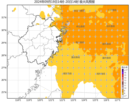
09-20 07:20...并将于今天(19日)傍晚到晚上在浙江象山到上海浦东一带沿海登陆(热带风暴级或强热带风暴级,9~11级,23~30米/秒),之后强度逐渐减弱。目前,浙江已发布96条气象灾害预警信号,其中54条为台风蓝色预警。中国天气分析,普拉桑经过一夜整合,结构比此前更加完整,今早已加强为强热带风暴,登陆点北调一些。登陆上岸后移速会减慢... 0
-
09-19 17:20...23-30米/秒),之后强度逐渐减弱。“普拉桑”路径概率预报图(央广网发来源:中央气象台)浙江省气象台预计,9月19日东海海域有9~10级局部11级阵风;19日浙中北沿海海面有8~9级局部10级阵风,沿海和浙中北部分地区阵风5~7级,江河湖面和高山区7~9级。19日到20日白天为降水集中期,全省有中到大雨,其中沿海和浙... 0
-
09-19 12:50...热带风暴“弗朗辛”影响墨西哥湾油气生产9日国际油价涨超1%正在墨西哥湾向北移动的热带风暴“弗朗辛”周一强度有所增加,迫使部分美国石油钻探企业撤离海上平台工作人员,并暂停该区域的部分原油生产。天气预报显示,“弗朗辛”可能于本周三增强为飓风,在美国得克萨斯州和路易斯安那州海岸登陆,或将给受灾地区的油气生产造成更大影响。受天... 0
-
09-19 12:10...今年第14号台风“普拉桑”(强热带风暴级),19日8时位于宁波市象山县东偏南方向约405公里的海面上,预计将以每小时40-45公里的速度向西偏北方向快速移动,强度逐渐增强,今天下午到晚上在宁波舟山一带沿海登陆(热带风暴级或强热带风暴级),之后强度逐渐减弱。受其影响,今天到明天白天沿海和浙中北地区部分大雨暴雨、局部大暴雨... 0
-
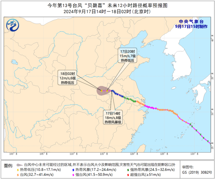
09-18 16:20...”中国气象局上海台风研究所副所长汤杰说。“‘贝碧嘉’登陆前‘绕’开了舟山群岛,且在近海没有减弱,几乎是以巅峰强度登陆。”汤杰告诉记者,台风登陆上海这样的中纬度区域,往往移速比较快且强度比较弱,多为强热带风暴和热带风暴,因此秋季有这么强的台风登陆上海非常罕见。具体来看,体积小但密度大是“贝碧嘉”的显著特点,这也使得“贝碧... 0
-

-
09-18 11:10...河南中东部、安徽西北部、山东西南部等地部分地区有大到暴雨,河南东部、山东西南部等地部分地区有大暴雨(100~220毫米)。明天,河南等地的降雨将趋于结束。专家提醒,河南、安徽西北部等地公众需继续提高警惕,防范局地强降雨可能引发的中小河流洪水、山洪、地质灾害及城乡积涝等,远离山区、河谷、地势低洼的地区,注意出行安全。图片... 0
-
09-18 07:40...早晨5点钟位于琉球群岛那霸市东南方向约630公里的西北太平洋洋面上,就是北纬22.8度、东经132.6度,中心附近最大风力有9级(23米/秒),中心最低气压为990百帕,七级风圈半径200-280公里。预计,“普拉桑”将以每小时35-40公里的速度向西北方向快速移动,强度有所增强,18日晚上移入东海东部海面,并将于19... 0
-
09-18 06:00...河南中东部、安徽西北部、山东西南部等地部分地区有大到暴雨,河南东部、山东西南部等地部分地区有大暴雨(100~220毫米)。明天,河南等地的降雨将趋于结束。专家提醒,河南、安徽西北部等地公众需继续提高警惕,防范局地强降雨可能引发的中小河流洪水、山洪、地质灾害及城乡积涝等,远离山区、河谷、地势低洼的地区,注意出行安全。公众... 0
-
09-18 03:00...而多台风相互作用会导致“普拉桑”和南海新生台风未来路径、强度及风雨分布预报均存在较大的不确定性。“贝碧嘉”可能在河南滞留徘徊据中央气象台消息,17日10时,“贝碧嘉”位于安徽省淮南市境内。预计,其将以每小时15公里左右的速度向西偏北方向移动,强度继续减弱,将于17日夜间移入河南省境内。王海平介绍,受“贝碧嘉”影响,17... 0
-
09-17 22:00...18日起移速减缓,18日晚上移入东海东部海面,19日下午到晚上将在浙江沿海登陆(强热带风暴级,10—11级,25—30米/秒),之后强度逐渐减弱。“贝碧嘉”继续深入内陆影响安徽河南等地今明两天(17日至18日),受台风“贝碧嘉”减弱后的残余系统影响,安徽、河南等地部分地区仍有强降雨,局地或现大暴雨。中央气象台继续发布暴... 0
-
09-17 20:30...普拉桑紧随贝碧嘉再次影响华东地区,上海、浙江、江苏和安徽等地台风灾害风险高,部分地区可能重复受灾,需高度关注。一、台风贝碧嘉以强台风级登陆上海浦东,是1949年以来登陆上海最强台风,将继续影响河南安徽等地今年第13号台风贝碧嘉于9月10日在西北太平洋洋面生成,之后一路向西北转偏西方向移动,强度逐渐增强;于16日7时30... 0
-
-
09-17 19:00...大风预报:9月16日20时至17日20时,黄海西南部、东海大部、长江口区、杭州湾以及浙江北部、江苏大部、安徽中北部、河南东部等地将有5-7级大风,阵风8-9级,其中江苏南部和安徽东部等地部分地区及江河湖面和山区的风力有8-10级,阵风10-12级。降水预报:9月16日20时至17日20时,江苏西部、安徽北部和东部、河南... 0
-
09-16 13:00...2022年第12号台风“梅花”是登陆上海强度最强的台风。2022年9月15日,第12号台风“梅花”于0时30分前后在上海奉贤沿海再次登陆,登陆时中心附近最大风力有12级(35米/秒),中心最低气压为975百帕。有网友说,经过一夜观察,“贝碧嘉”好像影响不大。气象专家解释,主要原因是“贝碧嘉”目前强风雨偏在它的东侧。随着... 0
-
09-04 02:30...该国东部和中部港口航船暂停运营。新华社发(乌马利摄)9月2日,在菲律宾黎刹省,人们搭乘货车通过积水的道路。热带风暴“摩羯”1日晚起侵袭菲律宾,引发暴雨和泥石流,截至2日已造成两人身亡、10人受伤。受此次极端天气影响,菲律宾多架次国内航班被取消,该国东部和中部港口航船暂停运营。新华社发(乌马利摄)9月2日,人们在菲律宾黎... 0
-
09-03 16:40...登陆时中心附近最大风力有14~15级(42~50米每秒,强台风级),之后穿过海南岛,7日凌晨移入北部湾海面,将给我国南海北部和华南南部带来强风雨影响。中央气象台3日18时发布台风黄色预警。根据《国家防汛抗旱应急预案》及有关规定,国家防汛抗旱总指挥部9月3日20时针对广东、海南两省启动防汛防台风四级应急响应。台风摩羯加强... 4
-
08-30 10:40...推荐阅读2024-08-2519:47:22央视新闻客户端2024-08-2514:04:58央视新闻客户端2024-08-2511:39:02新浪财经2024-08-2522:42:05央视新闻客户端2024-08-2309:58:03网易2024-08-2522:38:44网易2024-08-2522:34:27观... 0
-
08-24 19:10...中心附近最大风力有10级(25米/秒),中心最低气压为985百帕,七级风圈半径180-250公里,十级风圈半径60-80公里。预计,“珊珊”将以每小时10公里左右的速度向北偏西方向移动,强度逐渐增强,趋向日本四国岛以南洋面,未来对我国海域无影响。精彩推荐识别二维码关注青岛新闻网微信qdxww0532... 0
-
-
08-24 02:50...当天晚间最大持续风速为每小时137公里。据多家媒体报道,强风导致当地树木倾倒、电线受损,强降雨引发的洪水淹没了街道。当地公共汽车和轮渡已停运,机场将关闭至18日。不过据政府部门估计,此次飓风过境没有造成重大人员伤亡或财产损失。百慕大群岛由181个小岛组成,总人口约6.4万。飓风过境导致岛上大范围停电。当地电力供应商贝尔... 0
-
08-09 13:40...中心最低气压为977百帕。预计,“格美”将以每小时20公里左右的速度向北偏西方向移动,并将于今天傍晚至夜间由福建移入江西,而后继续北上,强度逐渐减弱。大风预报:7月26日08时至27日08时,黄海南部、东海大部、台湾海峡、台湾以东洋面、巴士海峡、南海大部、华东和华南沿海、长江口区、杭州湾将有7-8级大风,其中东海南部及... 0
-
08-06 20:30...“黛比”是继热带风暴“阿尔贝托”、飓风“贝丽尔”和热带风暴“克里斯”之后,2024年大西洋飓风季第四个被命名的风暴。美国国家飓风研究中心5日说,“黛比”在居民不足1000人的斯坦哈奇社区附近登陆,最大持续风速为每小时129公里,并以每小时17公里的速度向东北方向移动。据美联社报道,佛州5日晨约21.4万用户的电力供应中... 0
-
07-25 13:30...转为以防灾配置进行编组和设备配置。台军动用工程机械准备应对“格美”台风北京时间7月20日14时许,菲律宾以东洋面上的热带低压发展成为热带风暴,并正式获得编号,成为今年第3号台风“格美”(GAEMI),随后“格美”一路向西北偏北方向移动,分别在接下来的21日、22日和23日期间连续发展为强热带风暴、台风和强台风,并在今早... 0
-
-


-
本页Url:
-
2024-09-20-17:37 GMT . 添加到桌面浏览更方便.
-

