-
09-21 14:50...23日早晨最低气温降至17℃-19℃。市气象台昨日发布消息称,冷空气预计于今天中午前后抵达宁波,将带来明显的天气变化。宁波气温将显著下降,9月22日,最高气温或降至26℃-27℃,最低气温跌至20℃-22℃。冷暖空气交汇将引发一次降水过程。未来七天,宁波的天气以多云到阴为主,期间将有两次较为明显的降水过程,分别出现在9... 0
-
09-21 13:30...早晨5点钟其中心位于韩国全罗南道西偏南方向约345公里的黄海南部海面上,就是北纬33.7度、东经123.5度,最大风力有9级(23米/秒),中心最低气压为990百帕,七级风圈半径150-220公里。预计,“普拉桑”将以每小时30-35公里的速度向东偏北方向移动,强度变化不大,并将于今天下午在韩国南部沿海登陆(热带风暴级... 0
-
09-20 21:20...3928960欧洲多国对抗史诗级洪灾年09月20日09:45自当地时间2024年9月12日以来,奥地利、捷克、匈牙利、罗马尼亚和斯洛伐克的大片地区遭遇大风和罕见的强降雨。3928961欧洲多国对抗史诗级洪灾年09月20日09:45自当地时间2024年9月12日以来,奥地利、捷克、匈牙利、罗马尼亚和斯洛伐克的大片地区遭遇... 0
-
09-19 18:50...19日至20日,浙江、安徽、江苏、上海等地部分地区将有中到大雨,局地暴雨或大暴雨;9月19日08时至20日08时,黄海南部海域、东海大部、杭州湾、长江口区、浙江沿海、福建沿海、上海、江苏东南部将有6-8级、阵风9级的大风,其中东海北部和杭州湾及长江口的部分海域、上海沿海、浙江东北部沿海、江苏东南部沿海风力可达9-10级... 2
-
09-19 12:10...今年第14号台风“普拉桑”(强热带风暴级),19日8时位于宁波市象山县东偏南方向约405公里的海面上,预计将以每小时40-45公里的速度向西偏北方向快速移动,强度逐渐增强,今天下午到晚上在宁波舟山一带沿海登陆(热带风暴级或强热带风暴级),之后强度逐渐减弱。受其影响,今天到明天白天沿海和浙中北地区部分大雨暴雨、局部大暴雨... 5
-
09-18 18:10...预计“普拉桑”将以每小时45-50公里的速度向西北方向快速移动强度变化不大并将于19日下午到夜里在浙江沿海登陆风雨影响今天傍晚闽外渔场最大风力可达7~8级阵风9~10级今天夜里闽外渔场、闽东渔场东部最大风力可达8~10级阵风11级19日上午闽外渔场、闽东渔场东部最大风力可达8~9级阵风10~11级今天,副高减弱受台风“... 0
-

-
09-18 07:40...早晨5点钟位于琉球群岛那霸市东南方向约630公里的西北太平洋洋面上,就是北纬22.8度、东经132.6度,中心附近最大风力有9级(23米/秒),中心最低气压为990百帕,七级风圈半径200-280公里。预计,“普拉桑”将以每小时35-40公里的速度向西北方向快速移动,强度有所增强,18日晚上移入东海东部海面,并将于19... 0
-
09-18 02:30...偏北风3到4级,阵风5到6级,气温18~27℃。9月23日:晴天到多云,偏北风3到4级,阵风5级,气温18~27℃。9月24日:晴天到多云,偏北风3级,气温20~29℃。气温波动较大记得及时增减衣物又是一年中秋月又是万家团圆时节日期间家家设宴庆祝团聚很多人在吃上相对平时来说会比较放纵所谓“病从口入”在这里提醒大家关注我... 0
-
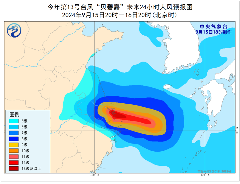
09-15 20:40...十级风圈半径80-100公里,十二级风圈半径40公里。预计,“贝碧嘉”将以每小时20-25公里的速度向偏西方向移动,强度还将有所加强,穿过舟山群岛后,将于16日早晨至上午在浙江舟山到江苏启东一带沿海登陆(台风级或强台风级,13-14级,38-45米/秒),最大可能以强台风级在浙江平湖到上海浦东一带沿海登陆(14级,42... 0
-
09-15 18:50...台风中心经过的附近海域13~15级;今天白天我市沿海海面风力逐渐增强至9~12级,夜里11~14级;杭州湾水面逐渐增强至8~10级,夜里11~13级;中北部沿海地区和高海拔山区逐渐增强至8~10级,夜里9~11级;内陆地区逐渐增强至7~9级,夜里8~10级。中央气象台也于今天06时继续发布台风橙色预警。登陆地点尚不确定... 0
-
09-13 02:40...今年第13号台风贝碧嘉(强热带风暴级)的中心今天(13日)早晨5点钟位于琉球群岛那霸市东偏南方约1130公里的西北太平洋洋面上,就是北纬21.1度、东经137.3度,中心附近最大风力有11级(30米/秒),中心最低气压为980百帕,七级风圈半径100-300公里,十级风圈半径60公里。预计,贝碧嘉将以每小时25公里左右... 0
-
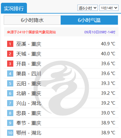
09-11 04:20...南岸、合川、铜梁、永川、綦江、南川、巫山等7个区县局地出现8级以上阵性大风,最大风速28.7米/秒(11级,合川燕窝11日02时)。大部地区最高气温超过37℃,江北、开州、云阳、巫溪等4个区县最高气温超过40℃,最高达41.0℃(开州)。据中国天气网数据显示,重庆高温还在持续,沙坪坝气象站首次在9月上旬出现高温全勤,巫... 1
-
-
09-09 22:40...我国台风预警信号分为四种。当有蓝色预警的时候,大风会使街边的树枝和电线剧烈摇晃,撑伞走路很难前行。黄色预警的时候,大风可能会使树枝折断,大家一定要小心高空坠物,不建议大家外出。预警升级到橙色时,狂风足以把街边的树木吹断,大家千万不要大意。最高级别的台风红色预警,平均风力超过12级,它带来的巨浪和风暴潮会严重威胁沿海地区... 0
-
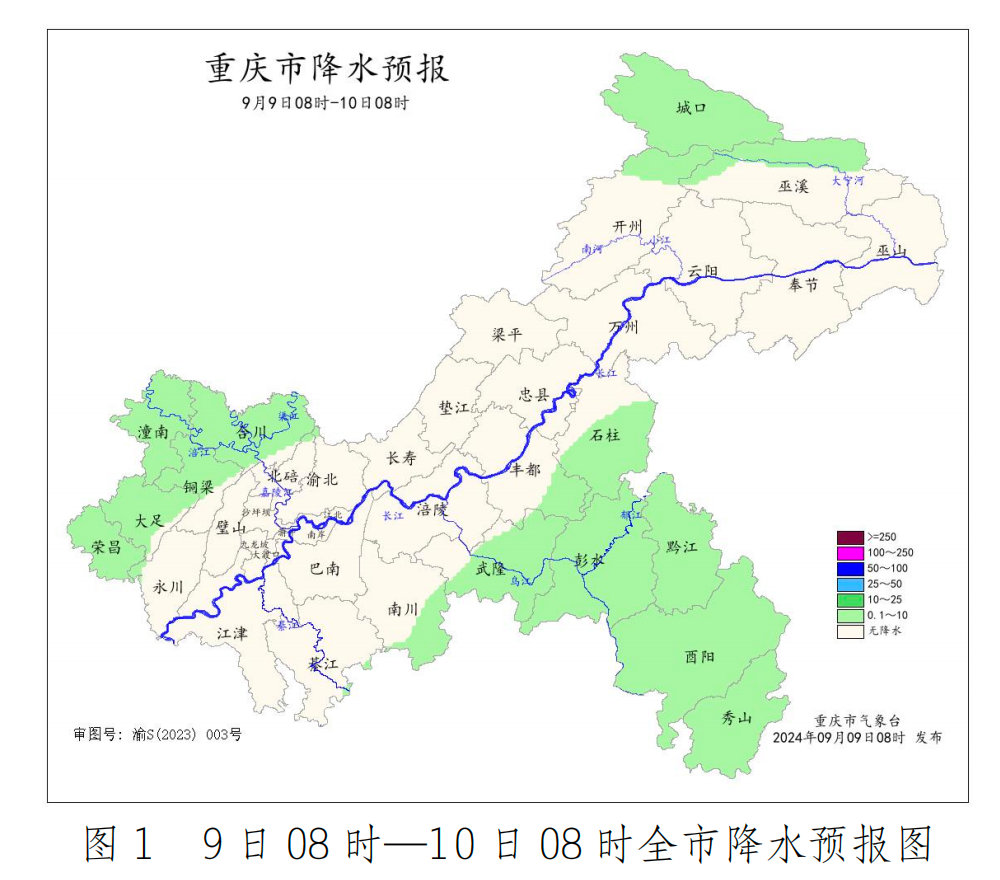
09-09 21:20...巴南、江津、綦江、奉节等4个区县的6个雨量站达暴雨。沙坪坝、南岸、北碚、渝北、巴南、合川、铜梁、大足、永川、璧山、江津、綦江、南川、长寿、垫江、梁平、忠县、万州、开州、武隆等20个区县的部分地区出现8~11级阵性大风,最大风速(11级,垫江永安6日19时)。江北、九龙坡、南岸、渝中、大渡口、北碚、沙坪坝、潼南、合川、铜... 0
-
09-09 20:30...江北、九龙坡、南岸、渝中、大渡口、北碚、沙坪坝、潼南、合川、铜梁、璧山、江津、綦江、长寿、涪陵、丰都、梁平、开州、云阳、巫溪、高新区、两江新区等22个区县最高气温超过37℃,最高达39.1℃(巫溪)。登陆越南后的“摩羯”昨天迅速减弱为热带低压,中央气象台已对其停止编号。看↓截至8日13时,9月5日以来“摩羯”制造了多少... 0
-
09-09 04:50...长时间超强,“摩羯”中心风速最强达到68米/秒(17级以上),且超强台风级的强度维持时间长达60多个小时(近3天)。(3)登陆强度强,“摩羯”先后以超强台风级登陆海南文昌、广东徐闻和越南广宁,是秋季登陆我国的最强台风,也是登陆我国第二强的台风(仅次于1409号“威马逊”),也是北部湾海面活动的最强台风。多次登陆:“摩羯... 0
-
09-08 08:20...并于7日下午在广西防城港到越南北部一带沿海再次登陆(台风级或强台风级,13-14级,40-45米/秒),之后强度快速减弱。大风预报:6日8时至7日8时,南海大部、广东西南部及广东沿海、海南岛及其沿海、广西南部及其沿海将有6-8级大风,南海北部和中部的部分海域、北部湾、琼州海峡、广东西部沿海、海南岛北部和东部沿海将有9-... 2
-
06-28 16:20...29日全省阴有阵雨或雷雨,沿江和江淮之间地区中到大雨,局部暴雨,其他地区小到中雨局部大雨;30日全省阴有阵雨或雷雨,其中沿江和苏南地区中到大雨,部分地区暴雨到大暴雨。过程雨量:江淮之间南部和苏南地区50~100毫米,局部120~180毫米;其他地区20~50毫米,局部50~70毫米。最大小时雨量50~70毫米。此外,2... 1
-
-
06-28 13:00...这台风机的大型主轴轴承、超长轻量叶片等核心部件均实现了国产化。此外,遍布整机的数百个传感器和机舱上的激光雷达,可以感知温度、湿度、风速等信息,数字化跟踪机组的运行状态,在恶劣气象条件下,还能通过机组自身的智慧“大脑”,进行风机角度、功率的调节。中国首个海上分散式风电项目地处台湾海峡与海坛海峡间的凸出部,“狭管效应”赋予... 6
-
06-28 10:40...山东省即将进入主汛期,各级各部门要牢固树立以人民为中心的发展思想,坚持底线思维,从思想上重视起来,强化组织领导和联动配合,压紧压实防范应对责任,做细做实防风加固和防雷、防雹等各项防范措施,确保人民群众生命财产安全。切实加强监测预报预警。气象部门要加强灾害性天气预测预报,加密雷电、大风、雨情、水情、地质灾害等监测频次,提... 3
-
06-26 07:20...并展示“AI追踪双目语音摄像头C60”等新产品。思必驰副总裁李春梅说,作为国内专业的对话式人工智能平台公司,思必驰拥有全链路的智能语音语言技术,去年获得科技部批复建设“语言计算国家新一代人工智能开放创新平台”。本次发布的新产品重点针对会议场景中的痛点,致力于为用户带来清晰、安全、高效的AI会议体验。人工智能迈入大模型时... 6
-
06-21 01:50...全省降雨量519.6毫米,较常年同期偏少31%,列历史同期第二少(最少为1963年495.5毫米)。各地市降雨量362.0~725.0毫米,较常年同期偏少28%至37%不等,其中偏少较多的有舟山362.0毫米(偏少37%),杭州494.3毫米(偏少34%),绍兴432.7毫米(偏少34%);偏少最少的为台州492.4毫... 2
-
-


-
本页Url:
-
2024-09-22-17:52 GMT . 添加到桌面浏览更方便.
-

